


Hiking in Mount Carleton Provincial Park

Cambellton, New Brunswick
As I mentioned in my last post, New Brunswick is often called the “drive through province”. As in, there’s not much to do there except drive through it to get to somewhere else. Well Mac and I were determined to not fall into that category. As soon as we crossed the J.C. Van Horne Bridge from Point-a-la-Croix, Quebec into Cambellton, New Brunswick, we set about looking for places to hike! Fortunately it didn’t take us very long. After a quick pit-stop in Sugarloaf Provincial Park, we spent a wonderful two days hiking in Mount Carleton Provincial Park and were left totally impressed with the scenery in New Brunswick!
Sugarloaf Provincial Park
Just south of Cambellton, and denoted by a rather large and eye-catching hill is Sugarloaf Provincial Park. While it’s a popular winter destination for skiing and snowboarding, the many hills and huge forests make for great summer hiking spots as well! If you’re more adrenaline-inclined, a popular activity in Sugarloaf is to take the chairlift up to the top of the ski runs and mountain bike down! I enjoy biking, but I’d rather do it on flat ground, thankyouverymuch. Instead, Mac and I tackled one of the many short hikes in the park. We hiked along the Terry Fox Memorial trail before trekking up to the top of Sugarloaf Mountain (242m). The views from the top were great and we could see along the Restigouche River all the way out to Chaleur Bay.


Hiking in Mount Carleton Provincial Park
South of Sugarloaf and east of Saint Quentin is Mount Carleton Provincial Park. The park is 174 square kilometers and is home to several lakes, campgrounds, trails, and mountains. In fact, the highest point in all of the Maritimes – Mount Carleton, 820m – is in this park!


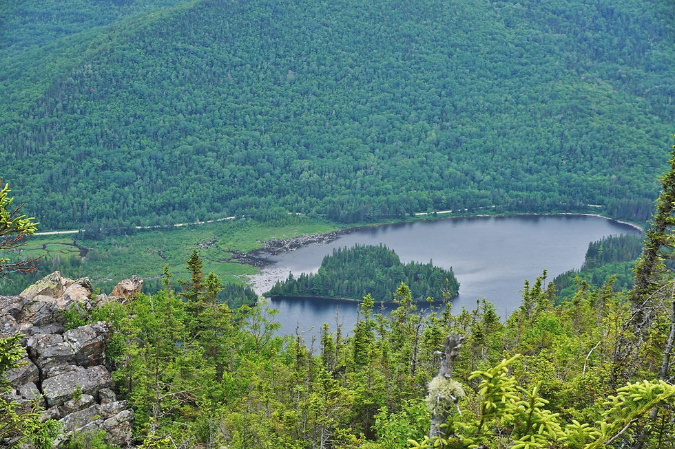
We treated ourselves to a campsite for a night (at an incredible deal) and set out to see what it was like hiking in Mount Carleton Provincial Park. Beginning at the car park of the Ruisseau Bald Mountain Brook trail, we hiked up, up, up to the ridgeline of the three main mountains in the park. From where we popped out in the forest, Mount Sagamook (777m) was just another kilometer away. There were some pretty incredible views at the summit over Nictau Lake as well as the neighbouring summits of Mount Carleton and Mount Head. We followed a little side trail that led to a lookout of Nictau Lake and the views from here were arguably better! From here we were able to see the lovely heart-shaped island in Indian Bay.

#gallery-8394-18 { margin: auto; } #gallery-8394-18 .gallery-item { float: left; margin-top: 10px; text-align: center; width: 50%; } #gallery-8394-18 img { border: 2px solid #cfcfcf; } #gallery-8394-18 .gallery-caption { margin-left: 0; } /* see gallery_shortcode() in wp-includes/media.php */


After leaving Sagamook Mountain, we continued to the summit of Mount Head (792m) where the rolling hills mountains stretched all the way to the horizon. I couldn’t believe how many trees there were! We read in the visitors’ center that from this ridgeline it was possible to see over ten million trees. I’ll admit I didn’t count them, but I have no doubt they’re there.


After Mount Head we faced a bit of a dilemma. Hiking to the Mount Carleton summit and back to the car was fairly ambitious – it had taken us longer than expected and it was nearing 6pm (and we were almost out of snacks). Instead, we came to a compromise. I would hike back down to the car via the same way we had come and Mac would continue on to Mount Carleton. There’s a trail that leads from the summit to another car park about 10km down the road from where we left our car. If we timed things correctly, we would both meet at the other car park around the same time (me with the car, and him via the trail).

Just as I was nearing our car the dark skies opened up and it started to rain. I picked up the pace a little bit and drove as fast as I could along the severely pot-holed dirt road to meet Mac. He showed up less than five minutes later – how’s that for timing?! While on the summit, Mac was able to check out the old and abandoned fire tower and look out over all of the Maritimes (theoretically, it was pretty cloudy).
#gallery-8394-19 { margin: auto; } #gallery-8394-19 .gallery-item { float: left; margin-top: 10px; text-align: center; width: 50%; } #gallery-8394-19 img { border: 2px solid #cfcfcf; } #gallery-8394-19 .gallery-caption { margin-left: 0; } /* see gallery_shortcode() in wp-includes/media.php */


We made dinner right there in the car park and cruised back to our campsite with full bellies, ready for a good night’s sleep! The next morning before we left the park, we made a quick pit stop at Williams Falls. This cascade is only 0.6km from the main road, and the wheelchair accessible trail made for some easy walking through the dense forest. The falls themselves were pretty impressive and we basked in the sun beaming through a gap in the trees.

Practical Information
There are many options for hiking in Mount Carleton Provincial Park. There are trail maps at the Visitors’ Center which is where you’ll have to stop to pay your entrance fee. If we had had more time, I would have liked to do the Mt Bailey trail. I heard that it’s a bit shorter and less of climb, but the views are still great.

A day pass (per vehicle) is $10
Our spot at Williams Campsite was $17 (really just $7 since we’d have to pay the $10 anyways!)
The camping pass is good until 8pm the day after your stay. You have to leave the campsite by 12pm, but you can stay in the park until it closes.
There are a few backcountry campsites if you’re feeling inclined to hike into them.
Tell me, have you ever mountain biked down a ski hill? Have you ever been to New Brunswick?
Pin It!

Never Miss a Post!
Enter your email address to subscribe to A Taste of Trace and receive notifications of new posts by email.
Email Address:
Sign Me Up!

Comments