


Discovering Sacred Hindu places in India –III : Kedarnath Dham and Haridwar

Hey everybody 🙂 As promised, here I am with the third part of my “Discovering Sacred Hindu Places in India” 🙂
In case you are visiting me for the first time, let me tell you that this post is the continuing part of my travels to sacred Hindu destinations in India.
Here are the links to the first and second parts:
Route of my 9-day (28 October – 5 November, 2023) travel journey through the North Indian state of Uttarakhand…

Places covered: Rishikesh, Devprayag, Rudraprayag, Karnaprayag, Nandprayag, Joshimath, Tapovan, Vishnuprayag, Badrinath Dham, Mana and Vasudhara Falls, high-altitude Deo Tal lake near Mana Pass, Joshimath-Gopeshwar-Chopta-Barasu route, Kedarnath Dham, Barasu-Rudraprayag-Rishikesh route and Haridwar.
In the earlier part, I had covered Rishikesh, and the Garhwal Himalayan destinations of Joshimath, Badrinath and Mana in Chamoli district…

So now, enjoy my travels to Kedarnath Dham in Rudraprayag district and the spiritual capital of Haridwar in Haridwar district 🙂 Happy reading 🙂
Places covered: Joshimath-Gopeshwar-Chopta-Barasu route, Kedarnath Dham, Barasu-Rudraprayag-Rishikesh route and Haridwar.
MY JOURNEY
02 November, 2023. 11:30 AM.
After a magical three days’ experience in Joshimath, Badrinath and Mana, I left Joshimath for the next destination…a small village called Barasu, on the way to Kedarnath Dham.
At 1:30 PM, I stopped for lunch at a lovely riverside place serving excellent food. Highly recommended… although I don’t remember the name of the place 🙂
My tableside view …

There are two routes for reaching Barasu. One goes via Gopeshwar, and is a scenic mountain road snaking past Chopta and Ukhimath. The second is a longer route via Rudraprayag, and goes past religious towns.

The narrow road via Gopeshwar had some terrible stretches. At one point near Chopta, the car stopped for a minor repair. I grabbed the opportunity to take a walk in the lovely surroundings…
Located at an altitude of around 2608 metres (8,556 feet), Chopta is a picturesque hill station nestled in the Garhwal Himalayas. It is also popularly referred to as the “mini Switzerland” of India for its lush green meadows and spectacular Himalayan views. During winter, the entire region is covered in snow.
Besides beauty, it is also rich in flora and fauna. It has been declared as an important bird-watching site by national and international conservation and biodiversity organisations.
Chopta is at the epicentre of the Panch Kedar – the five most sacred Shiva temples in Uttarakhand. On its left are the shrines of Kedarnath and Madmaheshwar and on the right, Rudranath and Kalpeshwar, and just above it, the Tungnath temple.
Located at a height of approximately 3,680 metres (12,073 feet), Tungnath is one of the highest temples of Lord Shiva in the world. It is accessed by a 3.5 km trail starting from Chopta and takes about 3 hours to reach.
A further climb of about 1.5 kilometres from Tungnath (around one hour climb) leads to the 3690 metres (12,106 feet) high Chandrashila (“Moon Stone”) peak, which offers breathtaking views of the Himalayas.
The Tungnath – Chandrashila trek is one of the most popular things to do in Chopta.
It was dusk at Chopta. The road passed by Ukhimath, a small but religious town and also the starting point for the trek to Chopta. Ukhimath is the winter abode of Lord Kedarnath.
The long journey from Joshimath finally came to an end when I reached Barasu at around 11 PM. For dinner, I had Lauki Kofta (spiced bottle gourd balls) curry with rice. It was the first time that I had lauki kofte… I had never heard of it before 🙂 It was so yummy that I decided to make it at home.
And I did… this is my delightful lauki kofta curry 🙂

Indian cuisine has such a vast repertoire of delicious vegetarian dishes that skipping non-vegetarian dishes becomes easy, especially on pilgrimage. While travelling in the Himalayan region, I have mostly or always chosen vegetarian over chicken dishes. Somehow greenies become more appetizing than ever before in the high mountains, where I shudder at the thought of a slaughtered chicken for meal 🙂
Early next morning, it was a five-minute drive to Sersi helipad, from where I boarded the helicopter to Kedarnath.
Related posts:
Kedarnath
Being part of the Himalayan region, Uttarakhand, is extremely vulnerable to natural disasters. Natural hazards, like earthquakes, landslides, avalanches, cloudbursts, hailstorms, Glacial Lake Outburst Floods (GLOFs), flash floods, lightning, and forest fires, etc. have been a cause of major disasters in the State.
On 16 June 2013, the State suffered one of the worst disasters in the living memory, causing widespread damage and destruction, besides heavy casualties. The entire State was hit by very heavy rainfall and flash floods. Though all the thirteen districts of the State were hit, five districts, namely Bageshwar, Chamoli, Pithoragarh, Rudraprayag and Uttarkashi were the worst affected.
The disaster caused heavy loss of precious lives and extensive damage to private properties and public infrastructure. More than nine million people were affected by the flash floods.
As per report made available by the State Government, a total of 169 people died and over 4,021 people were reported missing (presumed to be dead). A total of 4,200 villages were affected, 11,091 livestock were lost and 2,513 houses were fully damaged.
The disaster coincided with the peak tourist and pilgrimage season, significantly enhancing the number of the casualties and adversely affecting the rescue and relief operations. The impact of disaster was most pronounced in the Mandakini valley of the Rudraprayag district. Torrential rains, coupled with the probable collapse of the Chorabari Lake, led to flooding at the Kedarnath Shrine and the adjacent areas.
Other pilgrimage centres in the region, including Gangotri, Yamunotri and Badrinath, which are visited by thousands of devotees during the summer season, were also affected. Over one lakh people were stuck in various regions of the State due to damaged roads, landslides and flash flood-induced debris.
The suddenness of the flash floods coupled with the high velocity of flow laden with heavy sediment, including boulders washed away pilgrims and locals. Apart from flash floods, people were also reported to be killed by landslides, which buried them alive under huge debris and rock falls.
The difficult terrain and blockage of roads made it difficult to provide necessary relief to the survivors stranded at isolated locations. The harsh weather conditions i.e. continuous rainfall, chilling cold and non-availability of proper shelter/clothes contributed to the misery endured by the survivors of the disaster.
The disaster essentially occurred due to wide spread heavy rains during the period 14-18 June, which resulted in flash floods in all the major river valleys in the State. Heavy rains triggered major landslide at numerous locations causing severe disruption in surface communications. Extreme rainfall is not an uncommon phenomenon in the region. The heavy rainfall in the region was the result of convergence of the southwest monsoon trough and westerly disturbances, which led to the formation of dense clouds over the Uttarakhand Himalaya. The disaster was the result of extra precipitation in a very short duration of time, which resulted in heavy water discharge in various rivers and streams.
The Kedarnath area in particular was impacted the most as it suffered unprecedented devastation with very heavy loss of life and property. Kedarnath Dham township is located at an altitude of 3583m on the banks of the river Mandakini, which originates from the Chaurabari glacier – about 4 kilometers upstream. It is connected by a motorable road from Rudraprayag up to Gaurikund (40 kms) and thereafter through a mule track (14 kms), running along the Mandakini river. The river Mandakini joins river Alaknanda at Rudraprayag.
Search, rescue and relief operations during Uttarakhand disaster were the most difficult operations carried out in the Indian history of disaster management. Various Central and State level government and non-government agencies played a significant role in making this operation successful, despite difficult terrain, adverse weather conditions, disrupted roads and lack of telecom connectivity. Several ministries/agencies of the Central Government, departments/ agencies of the State Government, governments of other states, NGOs, and corporate sectors, all helped in the evacuation/relief operations. The State Government requisitioned the services of the Army, Air Force and Central Paramilitary Forces (ITBP, NDRF) on June 16 itself.
The efforts of the Indian Air Force, the Aviation Corps of the Indian Army and the civil helicopters engaged by the Civil Aviation Department of the State Government played a stellar role in the rescue operations. On June 25, an IAF helicopter (Russian-built Mi-17V5) crashed near Gaurikund due to bad weather, while dropping loads in the area. The chopper went down North of Gaurikund, at around 12.30 PM. All the 20 rescuers (05 from IAF, 06 from ITBP and 09 from NDRF), perished in the mishap.
The major part of the evacuation was accomplished in less than a fortnight making it one of the largest and swiftest rescue/evacuation operations by the civil administration.
More than 1,35,000 persons were evacuated from the affected areas in the shortest possible time, notwithstanding widespread destruction of roads, difficult terrain and extremely hostile weather. UAVs (Unmanned Aerial Vehicles) were deployed to scan the whole area of Kedarnath, mainly to identify the possible presence of survivors in the inaccessible areas.
The flash floods of June 2013 were one of the worst disasters to strike Uttarakhand. Though the disaster essentially occurred due to natural hazards, the vulnerability to the disaster was enhanced manifold by anthropogenic activities.

Standing magnificently at an altitude of 3,583 metres (11,755 feet) in the lap of the mighty Garhwal Himalayas, Kedarnath Dham is one of the twelve Jyotirlingas – the most sacred abodes of Lord Shiva – and the highest among them.
Kedarnath means “Lord of the field or Kedar Khand” region, the historical name of the region.
According to legend, after winning the Mahabharata war against the Kauravas, the Pandavas went to seek the blessings of Lord Shiva and for redemption from their guilt over killing their kith and kin during the war. Lord Shiva eluded them repeatedly and took refuge at Kedarnath in the form of a bull. On being followed, he dived into the ground, leaving his hump on the floor surface. This Hump inside the temple is in the form of a conical rock formation and is worshipped as Lord Shiva manifested in his “Sadashiva” avatar (form).
The remaining portions of Lord Shiva appeared at four other places and are worshipped there as his manifestations. The arms of the Lord appeared at Tungnath, the face at Rudranath, the belly at Madmaheshwar and his locks (hair) with head at Kalpeshwar. These five shrines make the revered Panch Kedar pilgrimage circuit.
Kedarnath Dham is among the 275 temples of Paadal Petra Sthalams (the most powerful Shiva temples in the world) and is also the most important among the Panch Kedars.
Being a high altitude region, winters are harsh in the Kedarnath region. The temple is covered with snow from November to April or May, making it inaccessible. Therefore, at the onset of every winter, which is normally towards the end of October or in the first week of November and on an auspicious date, which is announced in advance, the Murti (idol) from the temple is carried down in a doli (palanquin) from Kedarnath to Ukhimath, where it is worshipped for six months till April-May. Kedarnath Dham remains closed during this period.
In the first week of May and on an auspicious date which is announced in advance, the idol is carried back from Ukhimath to Kedarnath and reinstated in its original place. It is at this time, that the doors of the temple are thrown open to pilgrims, who arrive from all over the country (and from abroad too), for the next six months.
The pilgrimage to Kedarnath is considered to be one of the most arduous journeys, but it is also considered to be highly rewarding in terms of spiritual fulfilment. The temple and the divine surroundings enhance human faith in the Lord. In 2013, the temple survived one of the worst flash floods of all time in the state, thereby heightening its sacredness and mystique in the eyes of the devotees.
Kedarnath Dham is not directly accessible by road and has to be reached by a 16 kilometres uphill trek from Gaurikund. For those who are unable to trek the distance, there are mules and even porter services to reach the temple. A quicker alternative is by helicopter, which can only be booked online. https://www.heliyatra.irctc.co.in
Chopper services are available from Sersi, Phata and Guptkashi. However, bookings can be made only after the mandatory Char Dham registration is done. https://registrationandtouristcare.uk.gov.in
There are around eight companies operating helicopter services to Kedarnath Dham from Guptkashi, Phata and Sersi helipads. Sersi is the nearest to Kedarnath. It’s just a 5-minute ride.
I had booked my ride with Himalayan Heli Services, which operates from Sersi. The round trip fare was 5498 rupees with 9 AM departure from Sersi and 11 AM departure from Kedarnath. On the way to Kedarnath, there were 5 passengers (excluding the pilot) on board and on the return trip, 6 passengers. Photography is strictly forbidden.
In addition to its religious significance, Kedarnath is also known for its stunning natural beauty. It is situated amidst scenic Himalayan mountains and picturesque valleys covered with grassy meadows, with the Mandakini river adding to its natural charm.
The chopper ride was absolutely enchanting 🙂 Everything in a jiffy… mesmerizing vistas, splendid snow-clad mountain, lush greenery, the cemented pilgrim path snaking through the high mountains and more. A time-saving mode of travel, although I would have loved walking my way up in the tranquil and heavenly environment 🙂
Kedarnath Dham is just 700 metres from the helipad, within a walking distance of 5 or 10 minutes.
The temple is located near Chorabari glacier, which is the source of Mandakini river.

An imposing sight standing amidst lofty snow-covered peaks…

This much revered Lord Shiva temple is said to have been constructed by renowned 5th century BC Hindu saint and philosopher Adi Shankaracharya. One of the first references of Kedarnath Dham is in the Skanda Purana that was written around the 7th and 8th century AD. The temple stands next to the site of an even earlier temple that is said to have been built by the Pandavas.

The temple has been renovated many times over the centuries. It is built of massive stone slabs over a large rectangular platform.

That day, there was a heavy rush of pilgrims and the temple sanctum got congested. Poor me felt so suffocated… had to remove the jacket and unzip the sweater! I could have removed the sweater and long sleeved top underneath too with just a tee shirt on, but it was too crowded to even make that move. Still, I stepped into the restricted inner circle and stood next to the large statue of the Nandi Bull, Lord Shiva”s mount. I had no choice as I was gasping for breath, maybe because of a panic attack.
I lost my woollen cap, bought at Mana in the inner sanctum 🙂 But still, I got the chance to lay my head on the sacred Shiva linga 🙂 Well actually, a priest did that for me after I touched it by hand, paying my obeisance to the Lord. He just took my head and lightly banged it on the holy Shiva linga 🙂 I felt like a blessed coconut 🙂
Yours truly 🙂


Bhim Shila, a large rock formation located just behind the temple…

Bhim Shila stands for ‘God’s rock’, which saved the sacred Kedarnath Dham from being washed away by turbulent flood waters in 2013.
During the flood, the temple was at risk of being engulfed by the rushing water, sand, rocks, and mud. However, the massive rock acted as a barrier, dividing the force of the flood and preventing it from entering the temple premises. This fortunate occurrence saved the lives of hundreds of people, who had sought shelter inside the temple.
The presence of the rock, and how it came to rest at a specific distance behind the temple remain unknown. Some attribute this event to the divine intervention of Lord Shiva or Adi Shankaracharya, while others consider it a coincidence.
According to legend, the Bhim Shila is said to have been initially placed by the Pandavas. It is believed that the powerful Bhim, one of the five Pandavas from the Hindu epic “Mahabharata,” struck the ground with his might and created a spring that flowed into the nearby Mandakini River.
Whatever be the story, Bhim Shila continues to be a source of wonder and awe. It is regarded as a symbol of the temple’s resilience and a reminder of the miraculous events that occurred during the catastrophic flood.
Behind the rock lies the sacred resting place of Adi Shankaracharya, who established the sacred Char (four) Dhams in India, integral to Hindu pilgrimage. He is said to have achieved nirvana at this place at a remarkably young age of 32.
Shankaracharya Samadhi (final resting place)…

Adi Shankaracharya propounded the philosophy of Advaita Vedanta. Hence this site holds profound spiritual importance as his contributions shaped the spiritual landscape of Hinduism.
Mandakini flowing past the temple site…

Bhairavnath Temple (or Bhairon Baba Mandir), dedicated to Lord Bhairava – the powerful manifestation of Lord Shiva associated with destruction and devastation – is perched atop a hillock some 800 metres uphill from Kedarnath Dham. It offers scenic views of the surrounding Himalayas and the Kedarnath valley below.
By around 11:30 AM, I was back at Barasu. Soon after, I set out on the long journey to Haridwar.
The route…

Mandakini at Kund,, where a hydropower project is located on the river, flowing down on its way to Rudraprayag …

At around 3 PM, I made a lunch stop at Tilwara, which is about 20 minutes on the way to Rudraprayag. It was a nice restaurant with scenic views…


Food was delicious too…highly recommended for a break on the way to Kedarnath or back 🙂
An hour later, I was at the Sangam (or the confluence) of Alaknanda and Mandakini…

Being a religious place, Rudraprayag has numerous temples (mostly dedicated to Lord Shiva) in and around the town.
Located on the banks of Alaknanda, about 20 km on the way to Srinagar, is this revered temple dedicated to Dhari Devi (an avatar of Goddess Kali)…

Dhari Devi is considered as the guardian deity of Uttarakhand and is worshipped as the protector of the Char Dhams.
The temple was rebuilt following the devastating floods that hit the state in 2013.
Due to nightfall, the rest of my journey was covered in dark…
Haridwar
Located at the foot of the southernmost mountain chain of the Himalayas – the Shivalik Hills, the ancient city of Haridwar (“Gateway to Gods”) is the gateway to the Char Dham of Uttarakhand. Its roots are steeped deep in culture and traditions of the ancient Vedic times. It is a city of temples, and ashrams and institutions that impart traditional knowledge of wellness like Ayurveda, meditation and yoga.
Haridwar is also one of the holiest pilgrimages in India. It is from here that the Ganga – the holiest of all Indian rivers – enters the Indo-Gangetic plains. It is believed that the Ganga has divine energy to wash away peoples’ sins. Pilgrims and tourists throng the city ghats (stepped banks of a river) throughout the year for a holy dip in the river. The main ghats are Har ki Pauri, Vishnu Ghat, Ganesh Ghat, Birla Ghat and Gau Ghat.
In Hindu mythology, a few drops of heavenly nectar fell upon four places during the Samudra Manthan (or churning of the cosmic sea). Haridwar is one of those four holy cities (the other three holy cities being Prayagraj, Nashik, and Ujjain) that host the grand Hindu spiritual festival of Simhastha Kumbh Mela, which takes place once every 12 years in the Hindu calendar month of Chaitra(March–April). At that time, millions of devotees, including saints and monks from across the country gather here for a dip in the holy Ganga.
Offering prayers to the city’s presiding deity Lord Shiva, doing meditation, attending discourses and sermons, reciting scriptures, chanting of hymns from holy books, serving the monks and the poor, observing fasts and practising spiritual discipline assume importance during the time period spanning from Chaitra Poornima (Full Moon in March-April) to Vaishakh Poornima(Full Moon in April-May).
The Ardh Kumbh is organised here every six years. The annual Kanwar Mela is held here during the rainy season.
The ‘Panch Tirth’ or the five pilgrimages located within the periphery of Haridwar, are Gangadwara (Har Ki Pauri), Kushwart (Ghat), Kankhal, Bilwa Tirtha (Mansa Devi Temple) and Neel Parvat (Chandi Devi Temple).
At around 10:30 AM, I started for my city visits which included the revered hilltop temples of Goddess Chandi Devi and Goddess Mansa Devi, and the iconic Har ki Pauri ghat, where the renowned evening Ganga Aarti is held.
Both temples are ancient and famous Siddhpeeths (where desires get fulfilled), located atop the Shivalik Hills. They are two of the Panch Tirth (Five Pilgrimages) within Haridwar and can be quickly reached through a ropeway service called “Udan Khatola”.
The ropeway has been operational since 1981. Besides its extreme convenience to specially-abled and elderly devotees, the ropeway has become a major tourist attraction in the region and the preferred choice to reach the temples. It provides a bird’s eye view of Haridwar city and the Ganga.
A combined ticket to both temples comes at a discount. The ropeway amenities include wash rooms, drinking water, food courts, refreshment counters, first aid facilities, landscaped gardens and car parking.
I began with the Chandi Devi temple, situated atop Neel Parvat (Blue Mountain).
Yours truly near Chandi Devi Temple and against the backdrop of Mansa Devi Temple atop the hill…

View of Haridwar city…

On my way back to the ropeway station, I stopped for some mouth-watering food, which was beckoning me from the stalls 🙂
Delicious creamy lassi 🙂

Piping hot Bhature and spicy Chole…

It was very filling so I just had fresh lime soda during lunch. That was at the nice and spacious Khaira Dhaba. What impressed me most about this sprawling property was its excellence in cleanliness and hygiene 🙂 A highly recommended place 🙂
After lunch, I visited the much revered Mansa Devi Temple atop Bilwa Parvat (Bilva is a sacred leaf or fruit “Bael”, used as offerings to Lord Shiva). It is located facing Chandi Devi temple and the 3 km uphill path starts from the city’s old quarter, close to Har ki Pauri ghat
Mansa Devi temple is one of the most ancient and famous Siddhpeeth, where the Goddess is regarded as a wish-fulfilling deity. Hundreds of people visit this ancient temple every day.
For me, it was an amazing experience. Inside the temple, a priest handed me a Prasad basket (return offering) when I hadn’t even made any donation or offering at the altar of the Goddess. I hesitated thinking it belonged to some other devotee and I shouldn’t be taking it, But I accepted it when the priest loudly repeated that I accept the Goddesses’ “Prasad”. As I walked on, a man came from behind to tell me that it belonged to him. So I handed the basket to him. On reaching the main altar of the Goddess, a woman came along with that man and told me to keep the basket. She said that they had already collected their return offering. So I took the basket back from the man. That was it…I felt so happy 🙂
It is widely believed that the goddess fulfils the wishes of her devotees. Devotees tie a red thread inside the temple and make their wishes. When the wish is fulfilled, they return to untie and remove the thread.
I didn’t find the said thread to make wishes, but inside the basket there was a red chunni cloth. So I made a few wishes and tied the red chunni in a knot on the long grill, which was already covered with over a thousand red chunnis. Won’t disclose all my wishes, but one of them was to see my Starship at Starbase 🙂
Related post:
(After returning home from my trip, when I opened the small pack of prasad which was among the things inside the basket, I found this coin embossed with the image of the Goddess. Around it was this red and orange thread!

I removed the thread, repeated my wishes, put it around the coin again, and tied a knot like it’s done at the temple 🙂 )
Haridwar is famous for Har Ki Pauri (“Feet of the Lord”) ghat, which is the site of the grand Hindu festival Simhastha Kumbh Mela, that is held every 12 years.
Har Ki Pauri is also world-famous for its blissful Ganga Aarti (worship of Ganga) ceremony. Huge numbers of devotees and tourists throng the ghat to witness the sacred river Ganga being venerated with a beautiful Aarti (a holy Hindu ritual conducted with lamps) held every morning from 5:30 to 6:30 AM, and every evening from 6:00 to 7:00 PM. The evening ritual is very popular among tourists as the flickering lamps reflected in the river’s waters make for a mesmeric sight. The ringing of bells, blowing of conches and recitation of hymns, add to the sacred atmosphere.
When I visited the iconic ghat at around 3:30 PM, this was the view…


The water flow had been diverted for cleaning the river before the start of the Deepawali (Diwali) festival, which was just a couple of days away.
Ganga remained heavily polluted for years until a decade ago, when cleaning the river became a crucial issue under the leadership of Prime Minister Narendra Modi. While cleaning the river is a continuous task, it can be said that Ganga is much cleaner today than it ever was in the past decades.
By 4:30 PM, the river water was flowing in steadily for the evening Ganga Aarti…

By 5:30 PM, hundreds of people had already gathered on either side of the river and over the bridge to offer their prayers and witness the enchanting ceremony. The deeply spiritual atmosphere was a priceless experience 🙂
My sister had paid the billed amount of 1100 rupees for performing Aarti and I was eagerly waiting for the mesmeric hour.
The Ganga Aarti takes place in the Brahmakund area of Har ki Pauri, a sacred spot where the elixir of immortality Nector (Amrit) is said to have fallen on Earth during Samundra Manthan…

As the Aarti time neared, around half a dozen priests positioned themselves facing the river, flowing gently alongside the Brahmakund area, each holding a tall samai (traditional Indian oil lamp made of metal).
At 6:00 PM, the air resounded with the heavy ringing of temple bells and loud chanting of mantras while priests swirled their large samais in clock-wise movement, performing the spectacular aarti. My sister and I held on to our priest’s samai, which was burning hot even though the handle was wrapped in layers of thick cloth. The huge flames going up and down near my face were uncomfortably hot but I simply loved the amazing experience of performing the Ganga Aarti 🙂
Yours truly doing Ganga Aarti 🙂
People light small diyas (lamps) and set them afloat in the water…
Yours truly setting afloat a diya 🙂
After the wonderful Ganga Aarti at Har ki Pauri, I visited Pawan Dham, about 3 km away.
Established in 1970, this temple is famed for the exquisite mirror and glasswork and the elaborately garbed idols of Hindu deities.
I just couldn’t stop admiring this beautiful idol of Goddess Durga in a fabulous garb…

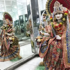
An optical illusion is created when you look to the sides…
There you see, the same idol appears a number of times across the view 🙂
Next day, on the way to Dehradun airport, I stopped at an old temple dedicated to Lord Satyanarayana – the manifestation of Lord Vishnu, who is also known as Narayana (or the one who symbolises eternal truth).
The main temple sanctum was closed but I saw the beautiful altar through the grilled door. The tall and captivating idols of Lord Satyanarayana and his divine consort Goddess Lakshmi, bedecked with colourful flowers, had me enthralled 🙂 It was such a blissful atmosphere with religious songs playing in the background… and a magnificent ending to my Badrinath and Kedarnath trip 🙂
A few minutes later, I reached the airport to catch my flight back home.
So guys… this was all about my Badrinath and Kedarnath trip 🙂 As promised, I will soon return with my “special” blogpost – an interesting report on the land subsidence problem in Joshimath and my views and opinions. Till then, take care 🙂 Keep visiting me 🙂
If you’re my first-time reader, don’t forget to follow my blog 🙂 Enter your email address and hit the “Follow” button and you will receive my new posts by email 🙂
Cheers 🙂
I hope you all are sharing my blog posts with friends and family. To make it more easier for you, tap this link A List Of All My Posts to check out the entire list of my posts 😀 You know, I’d hate to think that you missed something 😉
By the way, did you know that my four ebooks are available right here on my blog? And that you can buy and download them within a few minutes with just a few finger taps? 😉 Please do so right away 😀
You can read my travel experiences and learn more about the many beautiful destinations in Mexico in my ebook (PDF format):

CLICK Discovering Mexico US$ 16.97 (or the equivalent value in your currency)
HERE TO BUY: https://www.e-junkie.com/i/p6sy
To know all about Mexico, here’s my ebook (PDF format):

Mexico: The Country, Its History & The Maya World US$ 7.97(or the equivalent value in your currency)
CLICK HERE TO BUY: https://www.e-junkie.com/i/p6vh
For Mexico’s food history, detailed information on Mexican food & drink and a few recipes, buy my ebook (PDF format):

A Guide To Mexican CuisineUS$ 5.97 (or the equivalent value in your currency)
CLICK HERE TO BUY: https://www.e-junkie.com/i/p6vr
If you love reading romance novels and are a big fan of Mills & Boon novels, you will love my romance ebook (PDF format):

The Blue-Eyed Prince of NatlifeUS$ 4.99(or the equivalent value in your currency)
CLICK HERE TO BUY:
If you are a first-time visitor, I hope to see you again soon. Perhaps you might want to leave a like, comment, follow or hopefully all the three 😀
Remember, your feedback is highly appreciated. Your “Like” and comments are greatly valued. And let me tell you that I just love reading the warm words of appreciation that I receive for my work from my readers through the Contact Me Page 😀 So be generous with the feedback 😀
You can also connect with me on:
X (Twitter): https://twitter.com/swarupa007
Thanks for stopping by, I hope to see you back 😀 Till then, take care… cheers 😀

Comments