


Discovering Sacred Hindu places in India –II : Rishikesh, Joshimath, Badrinath and Mana

Hey everybody 🙂 I’m back with the second part of my “Discovering Sacred Hindu Places in India” 🙂
In case you are visiting me for the first time, let me tell you that this post is the continuing part of my travels to sacred Hindu destinations in India.
Here’s the link to the first part: Discovering Sacred Hindu places in India – I
If you’ve already read the first part, I’m sure you can’t wait to read this second part 😉
Happy reading 🙂
Today’s post is about my travels from Mumbai to Rishikesh – the yoga and wellness capital of the world – and to some of the most mesmerizing places of the Garhwal Himalayas in Chamoli district of Uttarakhand 🙂
Route of my 9-day (28 October – 5 November, 2023) travel journey through the North Indian state of Uttarakhand…

Places covered: Rishikesh, Devprayag, Rudraprayag, Karnaprayag, Nandprayag, Joshimath, Tapovan, Vishnuprayag, Badrinath Dham, Mana and Vasudhara Falls, high-altitude Deo Tal lake near Mana Pass, Joshimath-Gopeshwar-Chopta-Barasu route, Kedarnath Dham, Barasu-Rudraprayag-Rishikesh route and Haridwar.

Char Dham Yatra…
Also known as Dev Bhoomi or the Land of Gods, the beautiful Himalayan state of Uttarakhand is home to numerous Hindu temples and pilgrimage centres. This sacred land is written about in ancient Hindu scriptures and epics such as Ramayana and Mahabharata. It is deeply steeped in mythology, and hence connected with numerous thousands-of-years-old legends.
One of the most prominent pilgrimage in Uttarakhand is the Char Dham Yatra (In Hindi, ‘char’ means four, ‘dham’ refers to religious abode and ‘yatra’ means pilgrimage), an annual tour of four holy temple destinations – Yamunotri, Gangotri, Kedarnath and Badrinath – nestled high up in the Himalayas.
Char Dham Yatra is considered to be one of the most sacred in Hinduism and draws millions of devotees every year. It is also called “Chhota (small) Char Dham” to distinguish it from the original Char Dhams established in the four cardinal directions of the country – Badrinath in Uttarakhand, Rameshwaram in Tamil Nadu, Dwarka in Gujarat and Puri in Odisha.
The high-altitude Char Dham shrines of Uttarakhand remain closed for around six months every year. They open in summers (April or May) and close with the onset of winter (October or November).
It is believed that one should complete the Char Dham Yatra in a clockwise direction. Hence, the pilgrimage starts from Yamunotri, proceeds towards Gangotri, onto Kedarnath, and finally ends at Badrinath. The entire route starting from the ancient holy city of Haridwar to each of the four Dhams is marked by towns which are religiously important in Hindu faith.
With the arrival of monsoon from June until early September, all the pilgrimage routes starting from Haridwar receive heavy rainfall. Landslides and avalanches (resulting in roadblocks and sometimes even loss of life) are common during monsoon.
Char Dham Yatra registration is mandatory for the pilgrimage.

Dedicated to Goddess Yamuna, Yamunotri Dham is located in a narrow gorge close to the source of River Yamuna, the second-most sacred river in India.
Gangotri Dham is dedicated to Goddess Ganga, the most sacred of all Indian rivers, and is located close to the source of River Bhagirathi.
Kedarnath Dham is dedicated to Lord Shiva and is close to the source of River Mandakini.
Badrinath Dham is dedicated to Lord Vishnu and is close to the source of River Alaknanda.
Bhagirathi and Alaknanda merge at Devprayag to form the holy river Ganga, which flows down to the sacred city of Haridwar, passes through the ancient city of Kashi (Varanasi or Benares) in neighbouring Uttar Pradesh and unites with Yamuna in the holy city of Prayag (or Prayagraj) before continuing its onward journey to the Bay of Bengal..
Char Dham Yatra can be made by road. Additionally, a few hours of trekking is required to reach Yamunotri and Kedarnath Dhams. Helicopter services are available to all four dhams, subject to weather conditions.
Some devotees go on a “Do (two) Dham Yatra” to two shrines – Kedarnath and Badrinath, which is what I did 🙂
My travel plan…
My travel plan was to fly from Mumbai to Dehradun and drive straight to Rishikesh for a night stay. Start early in the morning for an eight-hour drive to Joshimath.
After two nights in Joshimath, start early in the morning on a two-hour drive to Badrinath Dham, and proceed to the nearby Mana village. And from there, trek to Vasudhara Falls and back. Next morning, a visit to the high-altitude Deotal lake near Mana pass, Mana village sightseeing and then back to Joshimath.
Next day, a long drive to the night halt at Barasu for an early morning helicopter ride to Kedarnath Dham from Sirsa helipad. On return, immediately start on a long drive to the next destination for a two-night stay to visit Haridwar before catching the return flight from Dehradun.
Adventure hub…
Besides religious tourism, Uttarakhand is also known as an adventurer’s paradise with exciting activities such as mountain climbing, trekking, river rafting, skiing, paragliding, bungee jumping, mountain biking, etc. While Auli is known as the skiing paradise of India, Rishikesh is known as the rafting capital of India as it offers rapids varying from easy to strenuous. It also has the country’s highest bungee platform.
In April 2023, the Indian Army and a team of Special Forces veterans, under ‘Conquer Land, Air, Water’ or CLAW Global, jointly launched a 3-month skill and high-altitude endurance challenge for civilians. A mix of military-style high-altitude operations and alpine adventure sports, it is the world’s first self-sustained, high-altitude skill, grit and endurance challenge at such glaciated and snow bound terrains. First, there is training in self-sustained style of mountaineering, survival, self-defence, navigation and emergency medicine. This is followed by an intensive training in ice craft including ice climbing, glacier negotiation, snow shelters, and search, rescue, and evacuation techniques. The final challenge is attempting summit on an unclimbed peak.
The numerous magnificent high peaks in the Garhwal and Kumaon Himalayas of Uttarakhand have attracted mountaineers for over two centuries.

Image credit: https://en.unesco.org/biosphere/aspac/nanda-devi
India’s second-highest mountain after Sikkim’s Kanchenjunga is Nanda Devi, which is also the highest peak located entirely within India. Kanchenjunga is located on the border of India and Nepal.
Nanda Devi (meaning “Bliss-Giving Goddess”) is the patron goddess of the Garhwal and Kumaon Himalayas.
Uttarakhand has six National Parks (including India’s first National Park, Jim Corbett), seven Wildlife Sanctuaries, four Conservation Reserves… and a Biosphere Reserve.
The Nanda Devi Biosphere Reserve includes Nanda Devi National Park and Valley of Flowers National Park, and is a UNESCO World Heritage site.
Related post: My Winter Holiday in Uttarakhand (Part I): Corbett
My Journey
Hiring a private car for the round trip from Rishikesh to Joshimath works out cheaper and is convenient as the vehicle is always at your disposal. Moreover, it does away with the hassles of hiring taxis at each point and wasting both time and money. Fortunately, I had an excellent driver from Rishikesh for the 9-day journey.
Along with me was my two-year older sister Swapna. We took an early morning flight from Mumbai to Dehradun, the winter capital city of Uttarakhand.
Rishikesh…
Rishikesh is at an hour’s drive from Dehradun’s Jolly Grant Airport.
Set against the backdrop of the Himalayas, on the banks of India’s holiest river Ganga, the ancient city of Rishikesh is one of the major tourist and pilgrimage hubs in northern India.

People from across the world come here in search of peace and to learn yoga and meditation at its numerous ashrams, some of which are internationally recognised as centres of philosophical studies, yoga and other ancient Indian traditions of wellness.
Rishikesh is called the “Yoga Capital of the World”. The massive international recognition came in 1968, when legendary English rock band “The Beatles“ visited Maharishi Mahesh Yogi’s ashram (now known as the Beatles Ashram) to learn transcendental meditation. The band composed nearly 48 songs during their time at the ashram, many of which appear on the White Album (and a few from Abbey Road). John Lennon recorded a song titled, ‘The Happy Rishikesh Song’ after his visit. Several other international artists, stars and celebrities have been visiting since then for inner peace, yoga and meditation.
The city’s annual International Yoga Festival attracts thousands of yoga enthusiasts, practitioners and gurus from across the world.
Every evening, as dusk descends, Ganga Aarti (a powerful and spiritual ritual on the banks of the sacred Ganges River) is performed at the three holy cities of Haridwar, Rishikesh, and Varanasi.
At Rishikesh, the Ganga Aarti is performed at Triveni Ghat and Parmarth Ashram. Hundreds of people turn up to watch the beautiful river-worship ceremony. Some luxury hotels and resorts, located alongside the Ganga, organize private Ganga Aarti for their guests.
Popular tourist areas include Tapovan and Upper Tapovan. Most of the places frequented by international travellers are dotted with small cafes and restaurants offering international cuisines. Adventure sports are aplenty and there are tour agencies at every nook and corner. River rafting is a must try sport in Rishikesh, for both beginners and experts.
I had visited Rishikesh earlier in 2007, while on a trip to Dehradun. Somehow Haridwar got skipped at that time.
For this trip, I had initially planned to begin the journey with Haridwar, but there was a lunar eclipse between 1:30- 3:30 AM on 29th October, which was a Sunday. It is customary for all temples to close their doors during the “Sutak” period, a nine-hour period of abstinence from worship before the start of the lunar eclipse. Hence all temples were closed at 4:30 PM on Saturday. It also meant no evening Ganga Aarti on Saturday.
Once the eclipse ends, people throng the Ganga for a customary dip in the course of the day.
Yours truly against the backdrop of mountains in Rishikesh 🙂

Ram Jhoola, a footbridge over the Ganga, connects Tapovan with Parmarth Ashram…

Alternatively, the river can be crossed by ferry. I went by ferry and returned by the bridge 🙂
Parmarth Ashram’s Hridalaya restaurant is an excellent place to stop for a bite. Close by, Chotiwala restaurant is a famous landmark too.
At dusk, I paid my respects to the holy Ganga and sent a small floral basket with a diya floating down the river…

Full moon night…

Uttarakhand is home to Panch Prayag (five holy confluences), where five rivers merge into Alaknanda river to ultimately form the sacred river Ganga, the major river of Northern India. The river provides water to 40% of India’s population, hence it is regarded as a lifeline of India.
Ganga is worshipped as the life-giving goddess and its waters are used in Hindu rituals. It is known as Bhagirathi in Gangotri, Mandakini in Kedarnath and Alaknanda in Badrinath.
Alaknanda is one of the two headstreams of Ganga, the other being Bhagirathi. Alaknanda flows for about 195 km before meeting Bhagirathi at Devprayag. After the holy confluence, the river is called Ganga.
Legend has it that when the goddess Ganga was requested to descend to Earth to help the suffering humanity, Earth was unable to resist the force of her descent. Therefore the mighty Ganga was divided into twelve holy channels. One of them being Alaknanda.
In hydrology, Alaknanda is considered as the source stream of Ganga due to its greater length and discharge. Its contribution to the water of Ganga is more than that of Bhagirathi, which is considered the source stream in Hindu tradition and culture.
Both Alaknanda and Bhagirathi are of vital importance in Uttarakhand. There are as many as 70 hydropower projects (including existing, under-construction and proposed dams) located on these two river basins alone. More than half of them on Alaknanda.
A turbulent Himalayan river, Alaknanda arises at the confluence and foot of the Satopanth and Bhagirath Kharak glaciers in the Garhwal Himalayas of Uttarakhand. Several streams and rivers merge with it on the journey down to Devprayag. The most revered are the Panch Prayag (five holy confluence of rivers), which in descending order of river convergence, are Vishnuprayag, Nandaprayag, Karnaprayag, Rudraprayag and Devprayag. It is believed that taking a dip in the Sangam (confluence) water at these five revered places cleanses the soul and brings them one step closer to moksha (salvation).
From its origin, Alaknanda flows to Mana village and meets with Saraswati river, a right bank tributary at Keshavprayag. It continues downstream through narrow valleys in the Badrinath valley, and meets with right bank tributary Ghritganga at Hanumanchatti. From here, it travels to Pandukeshwar, flowing through wide valleys and steep terrains. At Govindghat, it meets Laxmanganga.
Vishnuprayag is the first one among the Panch Prayag. Here, Alaknanda meets Dhauliganga, a left bank tributary, and travels west to Joshimath…

Near Helang, a small town to the south of Joshimath, Alaknanda crosses a major geological fault of the Himalayas called Main Central Thrust, and meets with Birahiganga, a left bank tributary, at Birahi village.
Reaching Nandprayag, Alaknanda unites with Nandakini, a left bank tributary…

At Karnaprayag, it meets with Pindar, a left bank tributary…

Named after Lord Shiva’s Rudra avatar, Rudraprayag is situated at the confluence of Alaknanda and Mandakini. Two separate routes bifurcate from here – one for Badrinath Dham (around 150 km away) and another for Kedarnath Dham (around 71 km to Gaurikund, and from Gaurikund to Kedarnath Dham by trekking along a paved path).
Mandakini, a right bank tributary, originates near Kedarnath Dham. It is the largest tributary of Alaknanda.
At Rudraprayag…
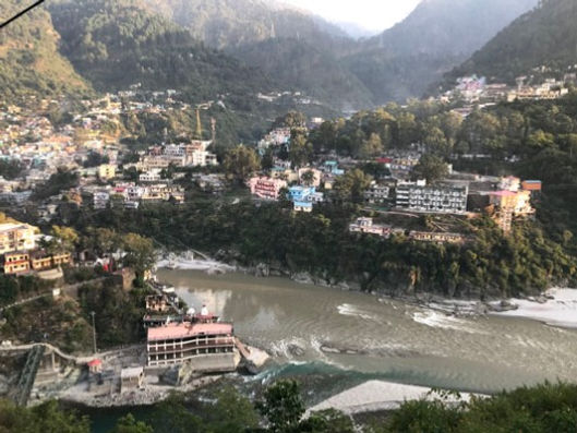

As Alaknanda flows past Rudraprayag, it enters a wide valley near Srinagar.
At Devprayag, Alaknanda and Bhagirathi rivers merge to form the holy River Ganga…

Devprayag literally means ‘God’s confluence’. It is an important religious site for Hindus as. Ganga, the biggest and the holiest river in India, starts its journey to the plains and further towards Bay of Bengal.

From Rishikesh, it takes around eight hours or so to cover the distance of 250 km to Joshimath. The road passes four of the Panch Prayag, starting with Devprayag, followed by Rudraprayag, Karnaprayag and Nandprayag. Numerous temples and religious sites dot the entire route.
To reach Joshimath before dusk, it is best to start from Rishikesh early in the morning.
I started off at 7:30 AM. Enjoy my videos of the five Prayags 🙂
Sangam at Dev Prayag: Alaknanda and Bhagirathi rivers
Confluence of the two rivers Bhagirathi and Alaknanda as seen from the road to Joshimath…
View from a footbridge…
Bhagirathi emerges from Gaumukh Glacier at the foot of Gangotri Glacier and Khatling Glacier near Gangotri Dham.
The absolutely gorgeous Bhagirathi…
Yours truly with Bhagirathi at Devprayag 🙂
The clear blue-green water is so cold and refreshing 🙂
I highly recommend stopping by Bhagirathi first before going to its meeting point with Alaknanda 🙂
Beautiful Sangam of Bhagirathi and Alaknanda 🙂
Alaknanda is brown because of the silt that it carries on its way down. From its origin and up to Joshimath its waters are blue and crystal clear.
Sangam at Rudraprayag: Alaknanda and Mandakini rivers
Mandakini rises from the Chorabari Glacier above Kedarnath Dham.
I visited the Sangam at Rudraprayag on the return journey from Kedarnath Dham to Haridwar. That’s because it is accessed through another road and diverting from the main road would have delayed my arrival in Joshimath.
Sangam at Karnaprayag: Alaknanda and Pindar rivers
Pindar originates from Pindari Glacier in the upper reaches of the Kumaon Himalayas in Bageshwar district.
Sangam at Nandprayag: Alaknanda and Nandakini rivers
Nandakini originates in the glaciers below Nanda Ghunti mountain, which lies on the outer rim of Nanda Devi Sanctuary.
Joshimath
Located at a height of 1,875 metres (6,152 feet), Joshimath is a beautiful ancient town surrounded by tall and towering mountains of the Garhwal Himalaya in the Chamoli district of Uttarakhand.
Religious significance…
Joshimath is the gateway to Badrinath Dham, and the holy Sikh shrine of Hemkund Sahib. The ancient town is said to have special spiritual powers, which is why renowned 5th-century BC Hindu saint and philosopher Adi Shnkaracharya spent five years here. He attained enlightenment at this place, which he named as Jyotirmath. (“Monastery of Light”). Jyotirmath went on to be called Joshimath.
Adi Shnkaracharya established the original Char Dham (four religious abodes) – Badrinath, Rameshwaram, Dwarka and Puri – and four Maths (monasteries) in the four cardinal directions of India. Apart from Joshimath, his other three Maths are at Sringeri in Karnataka, Dwarka and Puri.
Now I’m happy to say that I have been to all his four Maths and Dhams 🙂
Related posts:
Joshimath is revered by Hindus as an important pilgrimage centre of the country. It is the winter abode of Lord Badrinath (locally called “Shri Badri Vishal Ji”). Every winter, Badrinath temple is closed and the Lord’s image is carried in a palanquin and brought down to the town’s Narsingh temple, where it is installed and worshipped for the next six months.
Strategic significance…

Besides its religious importance, Joshimath is also of strategic significance. It is less than 150 kilometres from the Line of Actual Control (LAC) with China.
To guard this region covering around 250 kilometres of the LAC, Joshimath has an Army cantonment which plays a dual role of providing national security and humanitarian service in tough terrains and under harsh weather conditions. Highly skilled in mountaineering and mountain warfare along the border, the Army also provides vital support to the local administration in disaster relief operations.
During the Uttarakhand floods of June 2013 (which devastated the entire state and its economy), Joshimath served as a centre for the rescue missions carried out by the Army in Chamoli district, which was one of the five most affected districts. Hundreds of pilgrims were safely evacuated from Badrinath and Hemkund Sahib. Army aviation helicopters were used to establish a helicopter bridge at Govindghat which fast tracked evacuation operation to Joshimath significantly.
Later, during the Chamoli flood of February 2021 which resulted in nearly 200 deaths, the Army was the first to reach the National Thermal Power Corporation (NTPC) power plant in Tapovan, rescuing 35 people stuck inside a tunnel on that fateful day.
Heavenly significance…

Joshimath is also a gateway to several exceptional Himalayan mountaineering expeditions and trekking trails and for visiting the ski resort destination of Auli as well.
Besides spiritual treks to Badrinath Dham and Hemkund Sahib, popular adventurous treks include Har-ki-Dun, Valley of Flowers, Kuari Pass, Pangarchulla Peak, Bagini Glacier, Dharansi Pass and Kankul Pass.
One of India’s most popular and one of the oldest known treks is the Valley of Flowers, situated at an altitude of 3500 metres (11,483 feet). It is renowned for its outstanding natural beauty with meadows of endemic alpine flowers and mesmerizing mountain views. It remains open from June to October.
Valley of Flowers is a part of the Nanda Devi Biosphere Reserve, which also includes the Nanda Devi National Park, home to the 7816 metre (25,643 feet) tall Nanda Devi. The National Park is a glacial basin surrounded by a ring of 6,000m (19,700 feet) to 7,500m (24,600 feet) high peaks.

Image credit: https://indiahikes.com
Close by, the sacred Sikh shrine of Hemkund Sahib has a serene high altitude lake and is surrounded by majestic mountains. But the shrine had closed for winter a couple of days before. So the two places didn’t feature in my travel plan.
On the long journey from Rishikesh to Joshimath, I got delayed at several halts and reached Joshimath at night.
Early in the morning, I was bowled over by these spectacular views…


After breakfast, I started for Bhavishya Badri temple, 17 km southeast in Subhain village. It was a lovely drive through picturesque landscapes with stunning mountain views. The beautiful snow-capped Neelkanth peak instantly captured my heart. It was a distant view. I was mighty pleased when I was informed that I could get a very close view from Badrinath, where it towers over the temple, a short distance away :).
Brief outline of the beautiful Nanda Devi peak near the cloud…

Perched at an altitude of 2,744 meters (9,003 feet), the temple of Bhavishya Badri is surrounded by lofty mountains and lush green forests.

A short trek through pine trees leads to this small temple…

Bhavishya Badri (or “Future Badri”) is one of the Panch Badri (or five Badri) temples, a group of five sacred shrines dedicated to Lord Vishnu.
According to Hindu legends, in the ongoing Kali Yuga, the path to Badrinath Dham will become inaccessible due to natural calamities. Lord Badri (an incarnation of Lord Vishnu) will then manifest himself in the Bhavishya Badri temple. This prophecy adds to the mystique of the temple and attracts pilgrims seeking spiritual solace.
Inside the temple, Lord Badri is worshipped in a rock formation.

I took this photo unaware of the snow-capped mountain peak with clouds hovering over it…

And stopped here for these pictures, unaware that the same snow-capped peak was peering from behind 🙂


I noticed this charming detail only after I returned home from my trip 🙂 At first, I thought it was Nanda Devi. Now I think that perhaps it is the 7,066 metre (23,182 feet) tall Dronagiri (or Dunagiri) Mountain, which lies in the ring of peaks surrounding Nanda Devi 🙂
The beautiful Dronagiri Mountain is steeped in ancient lore. In the Hindu epic Ramayana, when Lord Rama’s younger brother Lakshmana was badly wounded in the battle against demon king Ravana in Lanka, the monkey god, Lord Hanuman was assigned the crucial task of bringing the mystical life-resurrecting herb, Sanjeevani Booti, from the Himalayas.
Sanjeevani Booti was a magical herb that could bring the light of life to the darkness of death. It had its own light source and would glow like the moon at night, disappearing long before the person locating it appeared and was projected by the Lords of Heaven themselves, who made sure the use of Sanjeevani was for the purpose of Dharma (righteousness) only. The only way to win Sanjeevani was with a pure heart. The herb had to be administered immediately and it seemed like an impossible task.
However, nothing was too difficult for Lord Hanuman, son of the wind god. Lord Hanuman’s love and dedication towards Lord Rama enabled him to overcome all challenges and hurdles and he was successful in bringing the herb for Lakshmana. Not wanting to waste any time in searching for the herb, he carried the mountain all the way to Lanka. The dying Lakshmana revived and immediately returned to the battle with renewed vigour.
Himalayan plants known for medical value…

Located at an elevation of 2,500 metres (8,200 feet) to 3,050 metres (10,010 feet) above sea level, the picturesque hill station of Auli is famous for its snow-capped mountains and skiing slopes. It attracts a large number of tourists from December to March, when the 4km long Auli ropeway connecting Joshimath is open for a thrilling 25-minute ride.
View of Auli (on the slopes of the left mountain close to the mountain in the centre) …

I skipped Auli as it was nearly lunchtime.
At Tapovan (14 km from Joshimath), I took this lovely photo of Dhauliganga flowing through the valley, unaware of the snow-capped peak watching in the background 🙂

Ten minutes later, I stopped at this hot spring. Later on, I learnt that there are two other hot springs in Tapovan. This was just a small one on the way.
The mud at the bubbling hot spring is said to be excellent for skin, so I collected a bit to carry home for testing 🙂
Remains of the long controversial Tapovan hydropower project which was under construction in February 2021, when a devastating flood caused by a glacier burst completely destroyed it…


Afternoon view at Joshimath
Evening view of mountains at Joshimath
In the evening, I visited the ancient Narsingh Temple…


This main temple of Joshimath is dedicated to Lord Vishnu in his fourth avatar – a half-man, half-lion avatar – called Narsingh or Narsimha avatar.
Inside the temple, the 10-inch high idol of Lord Narsingh in a seated posture, is self-manifested from a Shaligram Shila. The idol is said to have been installed by Adi Shankaracharya himself.
Shaligram Shilas are fossilized stones or ammonites found in the Gandaki River in Nepal. They are considered as sacred stones and are worshipped as manifestations of Lord Vishnu. These stones have a long history and hold immense religious significance in Hinduism, particularly in Vaishnavism. They are considered a medium to connect with the divine and receive blessings and spiritual benefits.
According to a legend, as long as the divine form of Lord Narsingh is present in the temple, Lord Badrinath will be worshipped at Badrinath. It is also said that the left wrist of Lord Narasimha’s idol is getting thinner day by day. And in Kali Yuga, when the wrist breaks, the two surrounding twin mountains will collapse and block the present road to Badrinath. After that, Bhavishya Badri temple will become the new Badrinath temple.
Within the temple precincts, about 30 metres from the Narasimha temple, stands the very ancient Vasudeva temple. It is one of the 108 Divya Desams – the highly revered Lord Vishnu temples recognized by the Vaishnava saints of Tamil Nadu.
The black carved stone idol of Lord Vasudeva stands about 6 feet tall. To the left of its entrance door is a carved stone idol of Lord Ganesh in a dance posture. It is said to be one of only two such idols in India.
As per tradition, pilgrims have to visit Narsingh temple first before proceeding to Badrinath. On learning this, I decided to visit the temple again the next day before proceeding to Badrinath It would also be a wonderful opportunity to get a good view of Lord Narsingh’s wrist when the garments, ornaments and floral arrangements on the deity are removed for the holy bath in a daily ritual ceremony called “abhishekh”, which is held between 7:30 and 8:30 AM.
After Narsingh temple, I visited the Shankaracharya Math (or monastery), located in the upper part of the town.
Adi Shankaracharya is considered one of the most influential philosophers in Hinduism and one of the foremost exponents of the Advaita Vedanta philosophy.
Vedanta is one of the most ancient spiritual philosophies and one of the broadest based on the sacred Hindu scriptures like the Upanishads, the Brahma Sutras and the Bhagavad Gita. It calls the Ultimate Reality as Brahman. Advaita Vedanta is one of its six schools of thought.
Advaita Vedanta emphasises non-duality and the unity of all reality. It is the most studied school of Vedanta in the modern era. Swami Vivekananda was one of its noted proponents in the Western world.
Although the dating of his birth and death is highly debated, evidence proves that Adi Shankaracharya lived in the 5th century BC. During his short life of 32 years, he travelled the length and breadth of India on foot, propagating his Advaita Vedanta philosophy, engaging in theological debates with leading proponents of other Hindu schools of philosophy and defeating them at it. He was responsible for reviving Hinduism in India to a great extent when Buddhism was gaining popularity and as such, is known as the father of Indian philosophy. Some of his finest works were written here at Jyotirmath.
Besides the temples inside the Math, I also visited the cave and the sacred 38-metre (125 feet) tall Kalpavriksha (Ficus benghalensis or Indian banyan tree) under which Adi Shankaracharya meditated. The tree is said to be over 2,500 years old. It has a huge trunk and its hollows are large enough for a person to stay within.
Kalpavriksha is a wish-fulfilling divine tree in Indian religions, like Hinduism, Jainism, and Buddhism. Because of its longevity, it is at the heart of India’s myths and legends.
Due to night-time and insufficient lighting, I couldn’t take photos of the Math visit.
Next morning, I was back at Narsingh temple…

It was a lovely ritual ceremony and an auspicious moment for taking blessings of the Lord before proceeding for Badrinath.
I experienced a warm glow of happiness as I started for Badrinath 🙂
The sacred town is about 44 km from Joshimath and it takes around 2- 2.5 hours to reach. On the way, I stopped at Vishnuprayag. This is where Alaknanda meets Dhauliganga, which originates from the Niti Valley, close to the LAC.
A bit ahead on the way to Badrinath is Govindghat, where Sikh pilgrims stop before proceeding to Hemkund Sahib, located picturesquely with a glacial lake and seven mountain peaks surrounding it.
Badrinath
Badrinath lies between the Nar and Narayana mountain ranges and in the shadow of a stunning mountain peak, Neelkanth. (A lovely bit about Neelkanth follows shortly, as you read on 😉
The area around Badrinath is referred to as Badari or Badarikaashram (Badri’s ashram) in ancient Hindu scriptures. The surroundings were known to abound in spiritual treasures.
According to legend, Badrinath gained prominence when Lord Vishnu’s dual form of Nara-Narayana meditated there. In those days, the region was full of berry trees. In Sanskrit language, berries are called “badari”. At the place where Nara-Narayana was meditating, a large berry tree grew up and provided him with shade and shelter.
Legend has it that Goddess Lakshmi took the form of the berry tree to save her beloved Lord Vishnu and to nourish him during his long penance in the harsh Himalayan climate. Hence she became “Badri Vishal” and her Nath (or Lord) became “Badri Nath”
The uphill road to Badrinath is lined with Sea buckthorn (Hippophae rhamnoides) trees.

Also called “Leh berry” (as it abounds in Leh-Ladakh too), the berry is sour in taste, but has many health benefits. And a great immunity booster due to its high content of Vitamin C 🙂
On reaching the town of Badrinath, my first impression was “Oh, how messy it looks!” The holy town is undergoing a major facelift. Extensive construction work is in progress for the Badrinath Master Plan project which entails beautification and development of key facilities at the sacred religious site. Here’s hoping everything goes absolutely great as per the plan… above all, without any damage to the natural environment in this fragile region 🙂
The pre-eminent abode of Lord Vishnu, Badrinath is situated at an altitude of around 3,100 metres (10,170 feet) in the Garhwal Himalayas, along the banks of the Alaknanda river…

The holiest of the holy Hindu shrines, established by Adi Shankaracharya – the Badrinath temple…


Tapt Kund, a natural thermal spring lies at the base of the temple, close to where Alaknanda flows….

Devotees take a dip here before entering the temple. It is said that the water of this spring has several medicinal values and cures many skin diseases.
As per legend, Adi Shankaracharya discovered a black stone image of Lord Badrinarayan made of Shaligram Shila in the Alaknanda. He enshrined it in a cave near the Tapt Kund. In the 16th century, the King of Garhwal moved the stone idol to the present temple.
The temple has undergone several major renovations with the passage of time and natural disasters. In the 17th century, the Garhwal kings extended the temple. Later, the King of Jaipur rebuilt the temple after it was almost destroyed by the Himalayan earthquake of 1803.
Although Badrinath is in North India, the Rawal (or head priest), is traditionally a Namboodiri Brahmin chosen from the South Indian state of Kerala. This tradition is believed to have been initiated by Adi Shankarachary, who was from Kerala.
Mana Village
Mana is a picturesque hamlet at a short drive of 4 kilometres north from Badrinath temple. It is the first Indian village along the Line of Actual Control (LAC) between India and China in this sector.

Located at an altitude of 3,200 meters (10,500 feet), on the banks of the Saraswati river, the natural beauty of this tiny hamlet is incomparable. It is like a hidden gem, tucked away up in the hills and standing still in time.
A dreamy setting of towering Himalayan peaks everywhere and a mysterious river Saraswati flowing by 🙂

There is no mobile connectivity here… no tourist hotels… just some village homes. Due to its high altitude, the weather remains cool throughout the year. During winter, the village become inaccessible as the entire region gets buried deep under snow. The locals move to lower areas and return only after the weather improves.
During my stay, the average daytime temperature was probably around 8-10 degrees Celsius, with the mercury dipping several degrees lower at night.
Apart from religious places, the highlight of my trip was the mesmerizing trek to Vasudhara Falls, located about five kilometres from Mana village. It was such a magical experience and such an exotic place that even as I’m writing this, I feel as though it was just a dream. Never before had I gotten so close to mountain glaciers 🙂 Wait a sec…
In July-August 2010, I had been to heavenly Ladakh and also visited the high-altitude Siachen Base Camp, whose mountain landscape is absolutely sensational 🙂
Siachen Glacier lies immediately south of the great watershed that separates the Eurasian Plate from the Indian Subcontinent in the extensively glaciated portion of the Karakoram, sometimes called the “Third Pole”.
In December 2010, while travelling through Arunachal Pradesh, I had been to the high-altitude Bum La Pass and experienced mesmerizing snow-covered mountain landscape…it was an awesome and memorable experience 🙂
And in September 2014, I travelled through Sikkim and fell in love with the magnificent Kanchenjunga 🙂
Still, the Garhwal Himalayas are simply mind-blowing… truly exceptional 🙂 Just wait till you see my videos as you read on 🙂
Related posts:
The mountains around Badrinath are clearly mentioned in the Hindu epic Mahabharata. Subsequent to the end of the battle of Mahabharata and handover of the reins of the kingdom to their next of kin, the five Pandava brothers and their consort Draupadi proceeded to Swargarohini, (“Chariot to Heaven”) peak in the Western Garhwal Himalayas. It is believed that on their journey, they passed through Badrinath and Mana.
According to legend, earlier there used to be a trail connecting the two temples of Badrinath and Kedarnath. A priest would perform his duties at both temples on the same day. When he displayed bad behaviour, Lord Shiva was displeased and installed a sky-high mountain between Badrinath and Kedarnath…. Neelkanth.
Named after Lord Shiva (Neel “blue” – kanth “throat”), the 6,507 metres (21348 feet) tall peak, dressed in luminous white, towers dramatically over the valley of the Alaknanda and above the Badrinath temple, just 10 km away.
In 1931, renowned mountaineer Frank S. Smythe described this peak as one of the most beautiful of Himalayan peaks, second only to Siniolchu of Sikkim, and dubbed her the “Queen of the Garhwal”.
Although substantially lower than the highest peaks of the region, Neelkanth is a major peak of the Garhwal Himalayas.
I visited Badrinath temple on the 31st at noon and the 1st (my Hindu birthday) at around 3 PM. On both occasions, the top of Neelkanth was enveloped by clouds.
Then, on the 2nd, my wish to see the beautiful “White Queen” without clouds came true. This happened more than 50 kilometres away from Badrinath, on the drive down after departing from Joshimath, when I was already missing the mountains of Joshimath and Badrinath region.
While wistfully surveying the passing mountains, I saw this icy spire and asked the driver if it was Neelkanth…

Neelkanth Mountain seen on the way after leaving Joshimath for Chopta
Imagine my joy when he replied affirmatively 🙂 🙂 🙂
I immediately stepped out for a good look and had to make it quick too because of the narrow mountain road.
Zoomed view of Neelkanth 🙂

Weeks later, back home, I was going through my photos and videos of the Vasudhara trek. On comparing nearest mountain locations on Google Maps with the images and videos that I had taken on the trek… I realized that Neelkanth was one of the closest mountain peaks on the trek!
View of the path going towards Vasudhara Falls from Mana village…

“Vasu” refers to Lord Vishnu’s Vasudev avatar. “Dhara” means “flow of a stream or waterfall” in Sanskrit. So Vasudhara literally translates to Lord Vishnu’s waterfall. The waterfall can only be reached by trekking.
Vasudhara Falls is mentioned in ancient scriptures too. It was a halt for the Pandavas. Sahadeva is believed to have given up his life near Vasudhara Falls.
The initial part of the trek is easy to walk. It becomes steep as it progresses and breathtakingly beautiful too 🙂 Stones of all sizes and shapes, glacial moraine, dry grass and shrubs…and highly rugged mountains with sharp, angular, and serrated ridges and narrow spurs!
The snow-capped mountains looked so stunning that I just couldn’t tear myself away from them 🙂 Chaukhamba, Janhukut, Balakun and even Satopanth Glacier 🙂 And somehwhere very close was Neelkanth, whom I missed!
Eyes of the Chaukhamba on me 🙂


Janhukut peak to the left… and Balakun to the right, beyond which lies the Satopanth Glacier…

Located at a height of aprroximately 3,657 metres (12,000 feet), the waterfall drops from a 120-metre (400 feet) high cliff. It is believed to turn away from people with impure hearts. So if the water falls on you, then you are a virtuous soul 🙂
Being the start of winter, the flow of water was low when I visited. During the monsoon season between June to September, the water fall is in its full glory.

The spring water is enriched with herbs, and has scientifically proven medicinal properties. I can vouch for its energetic value and heavenly taste. After downing just a few gulps of the cold water, filled in a 500 ml bottle, I felt instantly refreshed and rejuvenated 🙂
The sun was shining brightly above Satopanth Glacier so I took the blessed opportunity to do meditation…in the most beautiful location 🙂 🙂 🙂
The spring water flows into Alaknanda which starts from below Satopanth Glacier and travels towards Badrinath.

I wanted to climb right up to where the water was hitting the ground. It was close by and looked pretty easy to reach. But there were loose stones everywhere…and there were people standing below. I changed my mind knowing that if I were to climb my way up, it would trigger an avalanche of loose stones upon those standing below.
Just a few minutes earlier, a stone had dislodged from the top of the high mountain and bounced off the ground with a sonic sound, just a couple of metres above me, before falling down into the valley. Haha…I was hugging a huge boulder at that time 🙂
Instead of a shower below the waterfall, I collected the spring water in my hands and sprinkled it over my head. Someone had made a shivling in the snow, where I chose to pose for this photo…

The photo was taken from a long distance. While zooming on my face, I noticed the shivlinga photobombing me:) And I found this only after I had returned from the trek!
For a fit person, it takes about 3-4 hours to do a round trip. I had started at around 1 PM and reached at around 4:20 PM. That’s only because I had stopped frequently on the way to enjoy the scenic surroundings, and also to capture its beauty in digital form, some of which I have shared here 🙂
Being wintertime, dusk falls early at 6 PM. I started the return journey at around 5 PM and reached Mana village at 6 PM sharp. Walking down briskly, I couldn’t take in the scenic beauty like earlier. If only I had known about the mountain peaks to be seen on the trek!
The next morning, I got up at 6 AM. When I stepped outside, I was greeted by this heavenly sight 🙂
Both the moon and the white luminous mountain top were vying for my attention 🙂
At around 8:30 AM, I started for the famous pass of Mana which is located at a height of 5,632 meters (18,478 feet). Mana Pass was an ancient trade route connecting India and Tibet.
Today, it attracts trekkers and motorcycle enthusiasts. In absence of a required permit, tourists are allowed only till Mana village. Mana Pass is extremely close to the Indo-Tibet border, hence civilian entry is restricted.
Barren and rugged terrain along the Mana Pass road…

Mana Pass is currently the 3rd highest motorable pass or road in the world. It was the highest in India until the Umling La (at 5883 metres or 19300 feet) in Ladakh opened in 2017. The world’s 2nd highest is in Bolivia.
Deo Tal (“Lake of the Gods”) is a sacred lake, located just 3 kilometres short of Mana Pass Zero Point. Two other lakes, Rajas Tal and Nag Tal are also located close by.

Deo Tal is believed to be the origin of the mythical Saraswati river, hence it is considered as holy. It is surrounded by icy peaks and remains frozen all year round except for September.
Yours truly at Deo Tal…


On the way back, I stopped at Saraswati Gorge, the point where the mighty Saraswati river flows down with full force and disappears into the gorge.
At Saraswati Gorge …

Saraswati Gorge, the point where the mighty Saraswati disappears into the gorge
Below the gorge lies Bhim Pul, a huge rock bridge.
According to popular beliefs, Bhim – one of the five Pandava brothers of Mahabharata and also the most strongest among them – picked up a boulder and threw it between the gorge over the river, making an enormous bridge to connect the two hills and allow the family to continue their onward journey.
Bhim Pul is one of the biggest tourist attractions in Mana village.


Saraswati gushes out in the open from Bhim Pul and flows on to reach Keshavprayag, where it meets Alaknanda.
Confluence of rivers Saraswati and Alaknanda at Keshavprayag…

Close to Bhim Pul lie two other attractions connected with Mahabharata – Ganesh Gufa and Vyas Gufa. Both are natural caves and house small shrines.
Ganesha Cave is associated with Lord Ganesha, the son of Lord Shiva. According to mythology, Vyas Cave is where Rishi (or Hindu sage) Ved Vyas lived and composed the four Vedas and the epic Mahabharatha with the help of Lord Ganesha.
Nearby, the small village marketplace was lined with shops selling winter wear and traditional handicrafts.
One of my memorable moments in Mana was plucking this apple from the fruit-laden tree…

It was the sweetest apple that I have ever had in my life 🙂
I left Mana with a deep longing to return. And I felt the same sentiments for Joshimath too when I departed for Barasu the next day.
By the way, let me tell you that I have been working tirelessly for days on a blogpost related to the land subsidence problem in Joshimath. I had planned to put it in this post, but then, I changed my mind because this is a travel post.
Still, I can’t wait to share that post 🙂 I have done an immense lot of research for it… reading heavy-duty technical stuff and geology data and lots more. And I have given my views and opinions on the matter too 🙂 I will share that post after the third part in this travel series 🙂
So guys, that’s it for now 🙂 I’m sure that you must be wanting me to go on and on 😉 But I need to take a short break now 🙂 Stay tuned because I will return very shortly with the next post, wherein I will share my travels from Joshimath to Barasu, Kedarnath Dham and the spiritual capital of Haridwar.
Till then, take care 🙂 Keep visiting me 🙂
If you’re my first-time reader, don’t forget to follow my blog 🙂 Enter your email address and hit the “Follow” button and you will receive my new posts by email 🙂
Cheers 🙂
Next posts:
I hope you all are sharing my blog posts with friends and family. To make it more easier for you, tap this link A List Of All My Posts to check out the entire list of my posts 😀 You know, I’d hate to think that you missed something 😉
By the way, did you know that my four ebooks are available right here on my blog? And that you can buy and download them within a few minutes with just a few finger taps? 😉 Please do so right away 😀
You can read my travel experiences and learn more about the many beautiful destinations in Mexico in my ebook (PDF format):

CLICK Discovering Mexico US$ 16.97 (or the equivalent value in your currency)
HERE TO BUY: https://www.e-junkie.com/i/p6sy
To know all about Mexico, here’s my ebook (PDF format):

Mexico: The Country, Its History & The Maya World US$ 7.97(or the equivalent value in your currency)
CLICK HERE TO BUY: https://www.e-junkie.com/i/p6vh
For Mexico’s food history, detailed information on Mexican food & drink and a few recipes, buy my ebook (PDF format):

A Guide To Mexican CuisineUS$ 5.97 (or the equivalent value in your currency)
CLICK HERE TO BUY: https://www.e-junkie.com/i/p6vr
If you love reading romance novels and are a big fan of Mills & Boon novels, you will love my romance ebook (PDF format):

The Blue-Eyed Prince of NatlifeUS$ 4.99(or the equivalent value in your currency)
CLICK HERE TO BUY:
If you are a first-time visitor, I hope to see you again soon. Perhaps you might want to leave a like, comment, follow or hopefully all the three 😀
Remember, your feedback is highly appreciated. Your “Like” and comments are greatly valued. And let me tell you that I just love reading the warm words of appreciation that I receive for my work from my readers through the Contact Me Page 😀 So be generous with the feedback 😀
You can also connect with me on:
X (Twitter): https://twitter.com/swarupa007
Thanks for stopping by, I hope to see you back 😀 Till then, take care… cheers 😀

Comments